
Day-Hiking
Below are some great day hikes.
| Mile markers | Distance | Description |
|---|---|---|
| 28.1 (TH3 at US96) to 26.9 | 2.4 miles | The first mile of the trail from the west end is relatively flat without any major stream crossings, with an interesting railroad crossing at 26.9 when the trail joins the road. |
| 12.1 (TH2 at TX87 in Yellowpine) to 13.4 | 2.6 miles | A 2.6-mile round trip to Walnut Creek from the Yellowpine trailhead, with about half of it following the creek. |
| 0 (TH1 at Lakeview Campground) to 3 | 3 or 6 miles | This round trip from Lakeview Recreation Area to “Gilley’s Point” is a great introduction to the trail. With coordinated transport, this is a fine one-way 3-mile hike. |
| 19.4 to 23.5 | Up to 8.2 miles | This 4.1-mile section is the trail’s wildest and gets the least traffic. It is a beautiful walk along Curry Creek. There is direct access from FM2426, with parking on nearby forest trails. Alternatively, there is access from the forest roads off Tin Top Trail ( FR 114). Adventurers can continue past Little Creek (23.5) after a knee-deep wade. |
| 28.1 (TH3) to 23.5 | Up to 9.2 miles | A round trip from the west trailhead to Little Creek on a well-defined trail with brief periods on forest roads. |
| 12.1 (TH2) to 6.7 | 5.4 or 10.8 miles | A trip from the Yellowpine trailhead to “Five Points” where the trail crosses FM 2928. |
| 13.4 to 19.4 | Various lengths up to 12 miles. | This 6-mile section has various access points where parking is possible, and itineraries of any length can be followed. There is a beautiful pond near milepost 14 with fantastic spring flowers in March and April. Jones Cemetery at 14.9 has some fascinating history. The stretch between Fish Creek (15.8) and the 152/152A junction (16.6) takes you through a vibrant young forest. The trail’s high point is at 16.8. The historical logging operations around milepost 18 illustrate how the forest regenerates. |
| 0 (TH1) to 6.7 | 6.7 or 13.4 miles | A well-defined trail gently undulates as it leads the hiker along the peninsula. To make this a one-way trip, hikers can be picked up at “Five Points” where the trail crosses FM 2928, which is 1.5 miles from The Sportsmans Cafe. |
There is no designated trailhead between Walnut Creek (mile 13.4) and Little Creek (mile 23.5). This central ten-mile section of the trail is generally wilder than the end sections and includes some people’s favorite trail locations, such as the pond (mile 14.1), Jones Cemetery (mile 14.9), or the trail’s high point (mile 16.8). Trail access is possible from road crossings, but you need to consider the viability of parking.
Thru-Hiking
- If planning a thru-hike, there is little to choose between which direction you take. People have personal preferences, and a question to the TBTL Facebook Group will get responses.
- Consider doing a yo-yo hike, where you walk all the way along the trail and back again. The 56 miles is a rarely-found distance and negates the need for a shuttle. Parking your vehicle at TH2 in Yellowpine acts as a resupply point halfway through your hike.
Trail Running, Fast Walking, and Fastest Known Times (FKTs)
The trail is suitable for trail running or fast walking. The creek crossings make the terrain interesting! The trail records are recapped below.
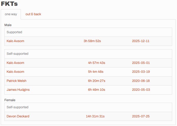
- Kalo Axsom has set the fastest overall known time in 3 hrs 58 mins 52 seconds, set on December 11th, 2025, supported by Bryan Oliphint.
- The current male self-supported FKT was also set by Kalo Axsom in May 2025 in 4 hrs 57 mins and 43 seconds. The current female self-supported FKT was set by Devon Deckard in July 2025 in 14 hrs 31 mins and 31 seconds, which must have been so hot, though much of it was hiked at night. Self-supported means that the person cached some food or water ahead of time.
- Kalo Axsom also holds the self-supported out & back record of 11 hr 40m and 54 seconds from May 1st, 2025, beating the previous record of 15 hr 17 min 35 seconds set by Patrick Welsh in June 2020.
- There currently are no unsupported records. In this category, you must carry everything you need from start to finish. You can use water from natural sources, but the USFS recommends against using water from the streams in this area.
Section Hiking
With the large number of access points and road crossings, a section hiker has many ways to divide up the trail. The larger creek crossings of Little Creek (23.5) and Walnut Creek (13.4) might influence an itinerary. Below is an example section-hiking itinerary without shuttle support, with each section being retraced:
| Section | Round-Trip Distance |
|---|---|
| TH3 (28.1) to Little Creek (23.5) | 9.2 miles |
| Forest Road 152 West (18.4) to Little Creek (23.5) | 10.2 miles |
| Forest Road 152 West (18.4) to Walnut Creek (13.4) | 10 miles |
| TH2 (12.1) to Walnut Creek (13.4) | 2.6 miles |
| TH2 (12.1) to FM2928 “Five Points” (6.7) | 10.8 miles |
| FM2928 “Five Points” (6.7) to Gilleys Point (3) | 7.4 miles |
| Gilleys Point (3) to TH1 (0) | 6 miles |
